Posts

Showing posts with the label Standing Stones

Top Ancient Sites in Oxfordshire

Image
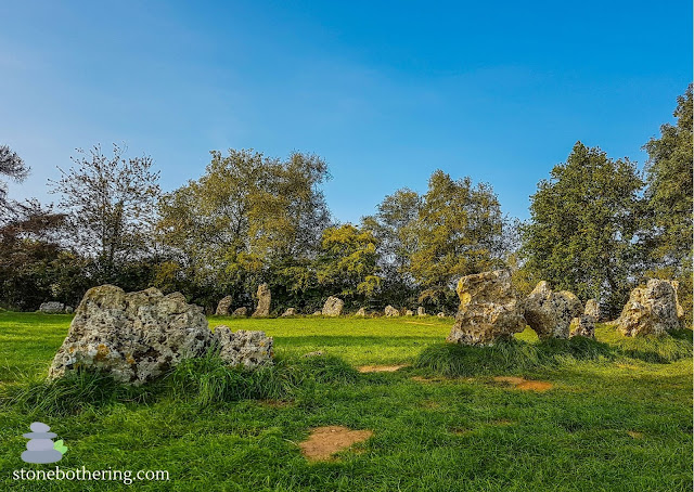
Oxfordshire is a landlocked county in the region of Southeast England. The county is mostly known for being home to the city of Oxford and its prestigious university. But the county is also home to extensive prehistoric landscapes and ancient sites. Here is a list of the top ancient sites in this amazing county. ROLLRIGHT STONES The Rollright Stones consist of a complex of three Neolithic and Bronze Age monuments. The monuments are known as the King's Men, the Whispering Knights and the King Stone. The three monuments were built at different periods in late prehistory from local oolitic limestone and had distinct purposes. The Whispering Knights was the first of the monuments to be constructed in the area. The monument consist of the remains of a Neolithic portal dolmen used as a place of burial. Evidence suggests that the Whispering Knights is one of the earliest funerary monuments in Britain. It was constructed around 3,500 BC. The King's Men Stone Circle is a circle of about

The Odd Stones of Staunton

Image
Staunton is a village in the Forest of Dean located near the English/Welsh border. This area is famous for the stunning woodland and for the large amount of stones, boulders and rock outcrops. Some of these are located in England and others in Wales. The Forest of Dean is formed of a raised basin of paleozoic rocks folded in the Variscan Orogeny. Underlain by great thickness of the Old Red Sandstone, the basin is filled with carboniferous limestone and sandstones. The majority of stones and boulders in the area are composed of Old Red Sandstone and quartz conglomerate. It's believed that they have mostly been formed by natural weathering over millions of years. The Staunton Longstone is a Bronze Age standing stone which stands near the A4136 road. Some people believe that the stone was once part of an ancient cemetery. Legend has it that if you prick the stone at midnight it bleeds. The Buck Stone is a local landmark and it's located along a walking trail near the village. It u

West Woods and the Sarsen Stones

Image
West Woods is a beautiful former ancient woodland site in the English county of Wiltshire. This area once contained a large amount of sarsen stones, but most of them have been broken up and removed. West Woods became famous as the source of most of the sarsen stones used to build Stonehenge. The sarsen stones are scattered across the woodland and they have been recorded by the archaeologists since 2007. One of the stones is known as the Polisher Stone (Polissoir). The stone contains grooved markings and has evidence of being used for shaping, whetting and polishing stone axes by older civilizations. The Wiltshire Archaeological and Natural History Society conducted a series of surveys which revealed considerable detail about the area and its surroundings. Evidence suggests that the woods have been visited by humans during different time periods including the Mesolithic, Neolithic and post-Medieval periods. West Woods is located near the market town of Marlborough. The woods are best en

Devil's Quoits

Image
The Devil's Quoits is a henge and stone circle in the county of Oxfordshire. It's believed that the henge is from the Neolithic Period, between 4,000 and 5,000 years old. The stone circle may have been put up at a later date, in the Early Bronze Age. The site was seriously damaged by the construction of an airfield in 1940. Excavations carried out in the 1970's and 1988, revealed the stone circle and the henge. The site was restored between 2002 and 2008, with stones which had fallen over being re-erected and the surrounding earthworks rebuilt. The name of the site is associated with a legend that states that the Devil once played quoits with a beggar for his soul and won by flinging the big stones. The Devil's Quoits is located near the village of Stanton Harcourt in England. © All rights reserved

Pen Y Beacon Stone Circle

Image
Pen Y Beacon Stone Circle is a stone circle in the Black Mountains. The circle is composed of one standing stone and three recumbent stones. In the past it was believed that these stones were the remains of a cairn but this theory is no longer accepted. Pen Y Beacon Stone Circle is located at the foot of Hay Bluff Hill, beside a car park near the village of Llanthony in Wales. © All rights reserved

Arthur's Stone and the legend of the giant

Image
Arthur's Stone is a Neolithic dolmen believed to be 5,000 years old. The tomb is topped by a large capstone which is broken with a large section fallen from its underside. The capstone rests on nine upright stones and weights more than 25 tonnes. These stones were once part of the inner chamber and they were once covered by a long earthen mound. It's unlikely that the monument was built solely as a tomb. It's believed that the Neolithic people could have gathered at the cairn to worship their ancestors. The tomb has never been excavated, but similar examples in this region have been found to contain human skeletal remains. Like many prehistoric monuments, Arthur's Stone has been linked to King Arthur. According to the legend, Arthur slew a giant on this spot. It's believed that the giant left the impression of his elbows on one of the stones as he fell. Arthur's Stone is situated on a hill near the village of Dorstone in England. © All rights reserved

West Kennet Avenue

Image
West Kennet Avenue was an avenue of two parallel lines of stones, which ran between the sites of Avebury and The Sanctuary. It's believed that the avenue was constructed around 2200 BC. West Kennet Avenue is part of a set of Neolithic and Bronze Age ceremonial sites that formed a large sacred landscape. They include Avebury Henge and Stone Circles, West Kennet Long Barrow, Adam and Eve Stones, among others. Excavations in the 1930s indicated that around 100 pairs of standing stones had lined the avenue. Many stones have fallen or are missing. As well as marking the route to Avebury, the stones seem to have function as grave markers. Some time after the avenue was constructed, several burials were placed at the foot of the stones. West Kennet Avenue is located near the village of Avebury in England. © All rights reserved

Avebury Henge and Stone Circles

Image
Avebury is a Neolithic henge monument containing three stone circles. It' s part of a set of Neolithic and Bronze Age ceremonial sites that formed a large sacred landscape. They include West Kennet Avenue, Adam and Eve Stones, West Kennet Long Barrow, among others. It's believed that the Avebury complex was constructed between 2850 BC and 2200 BC. The henge survives as a huge circular bank and ditch. Within the henge is the largest megalithic stone circle in Britain which in turn encloses two small stone circles. The Avebury monument is a UNESCO World Heritage site and it's situated around the village of Avebury in Wiltshire, England. © All rights reserved

Friar's Stone (Pedra do Frade)

Image
Friar's Stone (Pedra do Frade) is an intriguing monolith on a seaside cliff made up of a smaller stone balanced atop a huge boulder. The monolith weights 30 tons and it's about 9 meters high. Nobody really knows how the monolith ended up there and its inclined position defies the laws of gravity. There are many theories about the monolith but the most accepted one is that some rocks rolled down from the hill and one ended up on the top of the other. Erosion caused by wind and rain shaped the monolith along the years. Local legend has it that the monolith contains a treasure, deposited there by the Jesuits in the 17th century. The Jesuits  would have arrived in this area on a mission to integrate the indigenous population with the Christian faith. Friar's Stone is situated on a rocky cliff at the Praia do Gi near Laguna in South Brazil. © All rights reserved

Wayland's Smithy

Image
Wayland's Smithy is a Neolithic chambered long barrow which was built over an earlier wooden and earthen mortuary structure. It's one of many prehistoric sites associated with Wayland, the Saxon god of metal working. The long barrow is trapezoidal in plan and it's believed to have been constructed around 3600 BC by pastoral communities. The site is important as it illustrates a transition from a timber-chambered barrow to a stone-chambered tomb. The barrow was excavated twice and revealed the remains of fourteen skeletons. Analysis of these remains indicated that they had been subjected to excarnation which is the practice of removing the flesh and organs of the dead before burial. Wayland's Smithy is located near the village of Ashbury in England. © All rights reserved

Rollright Stones

Image
The Rollright Stones consist of a complex of three Neolithic and Bronze Age monuments located in two different fields on the borders of Oxfordshire and Warwickshire. The monuments are known as the King's Men, the Whispering Knights and the King Stone. The three monuments were built at different periods in late prehistory from local oolitic limestone and had distinct purposes. The Whispering Knights was the first of the monuments to be constructed in the area. The monument consist of the remains of a Neolithic portal dolmen used as a place of burial. Evidence suggests that the Whispering Knights is one of the earliest funerary monuments in Britain. It was constructed around 3,500 BC. The King's Men Stone Circle is a circle of about seventy stones constructed around 2,500 BC. It was used as a gathering place for Neolithic people. The King Stone is a monolith that was probably erected around 1,500 BC. It's believed that it was used to mark the location of a nearby Bronze Age b

Kilmartin Glen

Image
Kilmartin Glen is an area in the the county of Argyll containing the most important concentration of Neolithic and Bronze Age monuments in mainland Scotland. Monuments include standing stones, cairns, carved stones, among others. Over 5,000 years of human history has been preserved in this iconic landscape. There are numerous ancient monuments within a six-mile radius of the village of Kilmartin, with 150 monuments being prehistoric. NETHER LARGIE STANDING STONES The Nether Largie Standing Stones are a group of five large stones arranged to form the letter X. They are aligned on an approximately North East to South West axis. It's not clear why the stones were placed there. The most accepted theory is that the stones together form a lunar observatory, which marks where the moon will rise and set at certain points in its cycle. If this is the case, evidence suggests that the lunar observatory was built about 3,200 years ago. CAIRNBAAN CUP AND RING MARKS Cairnbaan Cup and Ring Marks

Stonehenge

Image
Stonehenge is one of the most famous landmarks in the United Kingdom and it's part of the most dense complex of Neolithic and Bronze Age monuments in England. Stonehenge is a prehistoric monument consisting of a ring of massive standing stones and horizontal stone lintels capping the outer circle. Two different kind of stones (bluestones and sarsens) were used to build it, Archaeologists believe it was constructed from 3000 BC to 2000 BC. Many modern scholars agree that Stonehenge was once a burial ground but they have yet to determine what other purposes it served and how they constructed this impressive monument without modern technology. Stonehenge is the most architecturally sophisticated stone circle in the world, while Avebury is the largest. Stonehenge is situated near the medieval city of Salisbury in Wiltshire. © All rights reserved

Stanton Drew Stone Circles and Cove

Image
Stanton Drew Stone Circles is considered to be one of the largest Neolithic monument to have been built in Britain. The monument was built about 4,500 years ago. Although being the third largest complex of standing stones in England, the site doesn't receive the same level of interest and exploration as the more famous stone circles at Avebury and Stonehenge. In 1740 the site was surveyed by the antiquarian John Wood, who suggested the layout was based on the Pythagorean planetary system of worlds. According to this theory, the number and position of the stones correspond to the solar, lunar and earth cycles. Astronomical alignments and ley lines are common theories to explain the positioning of the stones at Stanton Drew. However, recent surveys have revealed that the circles and cove were part of a much more elaborate and important ritual site than had previously been imagined. The Cove is a group of three large stones located in the garden of the village pub. It has been shown t

West Kennet Long Barrow

Image
West Kennet Long Barrow is a Neolithic chambered long barrow in the county of Wiltshire. It's one of the largest and most accessible tombs in Britain. It's believed that the barrow was constructed around 3650 BC as a burial chamber. The materials used in the construction were earth, local sarsen stones and oolitic limestone stones imported from the Cotswolds. The barrow was excavated twice and remains of at least forty-six individuals have been found alongside grave goods including pottery, beads and stone tools. West Kennet Long Barrow is situated on a prominent chalk ridge near Avebury Stone Circles in England. © All rights reserved